 ©2020 Biological and Chemical Oceanography Data Management Office.
Funded by the U.S. National Science Foundation
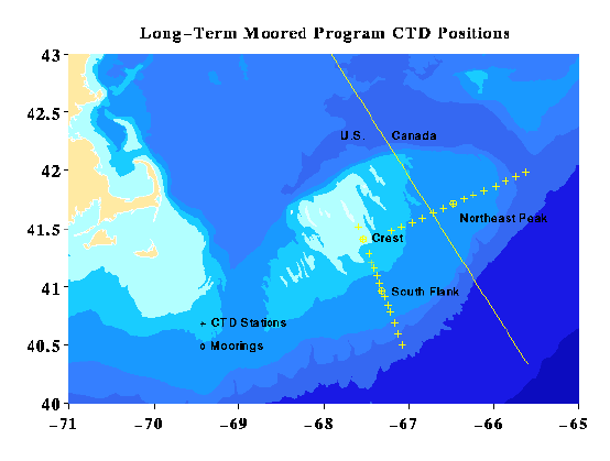
Standard CTD Sections

Long Term Section Stations
	LT01 41 31.0 N x 67 36.0 W
	LT02 41 24.5 N x 67 32.5 W
	LT03 41 17.0 N x 67 28.5 W
	LT04 41 12.5 N x 67 26.5 W
	LT05 41 09.5 N x 67 24.5 W
	LT06 41 06.0 N x 67 22.5 W
	LT07 41 02.0 N x 67 20.8 W
	LT08 40 58.0 N x 67 19.0 W
	LT09 40 54.5 N x 67 17.0 W
	LT10 40 50.5 N x 67 15.0 W
	LT11 40 47.0 N x 67 13.0 W
	LT12 40 41.5 N x 67 10.5 W
	LT13 40 35.7 N x 67 08.0 W
	LT14 40 30.0 N x 67 05.0 W

NE Peak Section Stations
	NE01 41 28.52 N x 67 12.17 W
	NE02 41 31.02 N x 67 05.77 W
	NE03 41 33.32 N x 66 57.77 W
	NE04 41 35.52 N x 66 50.87 W
	NE05 41 38.12 N x 66 43.07 W
	NE06 41 40.32 N x 66 35.97 W
	NE07 41 42.72 N x 66 28.77 W
	NE08 41 45.12 N x 66 21.67 W
	NE09 41 47.42 N x 66 14.37 W
	NE10 41 49.72 N x 66 06.67 W
	NE11 41 52.02 N x 65 58.87 W
	NE12 41 54.62 N x 65 51.77 W
	NE13 41 56.82 N x 65 44.57 W
	NE14 41 59.20 N x 65 37.50 W
Data submitted by:
James Irish
Woods Hole Oceanographic Institution
Woods Hole, MA 02543

phone:  508 289 2732
fax:    508 457 2195
e-mail: jirish@whoi.edu

Updated July 14, 2005, gfh
Irish, J. (2005) CTD data collected during 12 long-term mooring cruises to Georges Bank as part of the U.S. GLOBEC project on R/V Columbus Iselin, R/V Endeavor, R/V Seward Johnson, R/V Albatross IV, and R/V Oceanus from 1994-1999 (GB project). Biological and Chemical Oceanography Data Management Office (BCO-DMO). (Version 2005-07-14) Version Date 2005-07-14 [if applicable, indicate subset used]. http://lod.bco-dmo.org/id/dataset/2403 [access date]
Terms of Use
This dataset is licensed under Creative Commons Attribution 4.0.
If you wish to use this dataset, it is highly recommended that you contact the original principal investigators (PI). Should the relevant PI be unavailable, please contact BCO-DMO (info@bco-dmo.org) for additional guidance. For general guidance please see the BCO-DMO Terms of Use document.